
US-395 at Coleville / SR-108 Sonora Junction
Live camera on US-395, with the current status of the road it sits on and the forecast at the nearest pass.
Storm alerts
A notification on this device when chain control starts, changes or lifts, or a road closes or reopens. Pick your roads:
An alert is a heads-up that something changed, not a road report, and it can arrive a few minutes after the change. Before you drive, check Caltrans QuickMap or Nevada 511 (nvroads.com), or call 511. A few alerts a day at most; no account, no email, and you can turn them off here any time (what we keep).
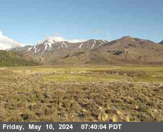
Image taken (checked ); a new one about every minute.
Weather at Bridgeport
- Today
- Sunny
- Temperature
- 67°F
- Wind
- 0 to 5 mph
- Zone
- CAZ073
This forecast could not be refreshed on the last run and may be out of date.
Forecast read
Where this camera is
This camera is the red marker; the blue dots are the other cameras on US-395. Click one to open it.
What this camera shows
This camera sits at 6,902 feet, making it the highest point in this immediate sequence of monitors. While the lower cameras at Leviathan Mine and Bridgeport often show clear conditions, this position is significantly more exposed to the elements. If you see accumulation or active precipitation here, it is a reliable indicator that the higher terrain is likely experiencing more severe weather than the surrounding valley floors. Because this is a still image that refreshes approximately once a minute, a dark or obscured frame may simply be a temporary result of local fog or heavy snow rather than a permanent road closure.
Drivers should compare this view against the lower elevation cameras to gauge how rapidly conditions are deteriorating as you climb. If this view shows wet pavement while the lower monitors remain dry, expect the weather to worsen quickly as you continue driving. Conversely, if the screen appears completely black or shows heavy static during nighttime hours, it is best to refresh the page a few times to confirm if the view is obstructed by blowing snow or if the camera has temporarily lost its link.
The cameras either side

More cameras on US-395
- US-395 at Airport Rd
- US-395 at Gardnerville RWIS
- US-395 at Lee Vining / Conway Summit
- I580 at 2nd St Intersection
- I580 at 5th St
- I580 at Arrowhead
Other roads
Camera: Caltrans. Chain-control status and closures: Caltrans District 9 (public domain) and Nevada DOT / nvroads.com. Nevada Explorer is not affiliated with any of them. Always confirm at roads.dot.ca.gov or nvroads.com before you travel.